Québec - Montréal - Saint-Laurent River - Lake Ontario - Niagara Falls
Carte interactive
Profil de la trace GPS
À propos de cette trace GPS
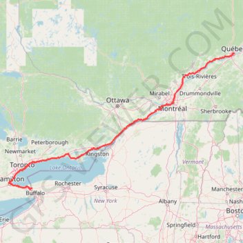
Nom : Trace GPS Québec - Montréal - Saint-Laurent River - Lake Ontario - Niagara Falls, itinéraire, parcours
Coordonnées : 43.08778 -79.89248 46.82520 -71.19960
Autres traces GPS
Cliquez sur une trace GPS pour visualiser son itinéraire, ses statistiques et son profil.
Corinth Reservoir
United States > New York > Saratoga County > Town of Corinth
Distance : 7,0 Km • Dénivelé positif : 206 m • Altitude maximum : 398 m
Bike ride to 50 point and back
Canada > Ontario > Niagara Region > Grimsby
Distance : 31,7 Km • Dénivelé positif : 237 m • Altitude maximum : 209 m
Webster Park
United States > New York > Monroe County > Town of Webster
Distance : 2,9 Km • Dénivelé positif : 22 m • Altitude maximum : 100 m
Bike ride losely along greenbelt trail
Canada > Ontario > Niagara Region > Grimsby
Distance : 24,5 Km • Dénivelé positif : 200 m • Altitude maximum : 206 m
Allen Mountain
United States > New York > Essex County > Town of Newcomb
Hike / snowshoes from East River Parking to Allen Mountain via East River Trail, Hudson River, Lake Jimmy, Lake Sally, Allen Mountain Trail and Allen Lookout North in the High Peaks Wilderness and the Adirondack Park. #Hike #Snowshoes #Mountain #Nature #Forest #Lake #River #Park #Wilderness #Adirondack
Distance : 28,7 Km • Dénivelé positif : 1 060 m • Altitude maximum : 1 302 m
Toronto Cycling
Distance : 39,0 Km • Dénivelé positif : 356 m • Altitude maximum : 124 m
Mount Washington, Lion Head and Tuckerman Ravine Loop
United States > New Hampshire > Coos County
Loop hike from Pinkham Notch to Mount Washington via Tuckerman Ravine Trail, Crystal Cascades Falls and Lion Head Trail in the Pinkham Notch Scenic Area, the Mount Washington State Park and the White Mountain National Forest. #Hike #Loop #Mountain #Nature #Forest #Falls #Park
Distance : 12,6 Km • Dénivelé positif : 1 325 m • Altitude maximum : 1 911 m
Orford, QC, sentier du ruisseau des chènes
Canada > Québec > Memphrémagog > Austin
Randonnée en aller-retour depuis Austin. #Randonnée
Distance : 10,1 Km • Dénivelé positif : 751 m • Altitude maximum : 840 m
Mount Liberty and Mount Flume
United States > New Hampshire > Grafton County > Lincoln
Hike to Mount Liberty and Mount Flume via Franconia Notch Bike Path, Liberty Spring Trail and Franconia Ridge Trail in the Franconia Notch State Park and the White Mountain National Forest. #Hike #Mountain #Nature #Forest #Park
Distance : 14,3 Km • Dénivelé positif : 1 181 m • Altitude maximum : 1 329 m
Trois-Rivières - Québec
Canada > Quebec > Trois-Rivières
#Bike
Distance : 138,5 Km • Dénivelé positif : 838 m • Altitude maximum : 108 m
Saddleback Mountain
United States > New York > Essex County > Town of Keene
Hike from Garden Parking Area to Saddleback Mountain via Phelps Trail, Orebed Brook Trail and State Range Trail in the Johns Brook Primitive Area, the High Peaks Wilderness and the Adirondack Park. #Hike #Mountain #Nature #Forest #River #Park #Wilderness
Distance : 24,5 Km • Dénivelé positif : 1 085 m • Altitude maximum : 1 361 m
Mont Chauve par le ruisseau David
Canada > Québec > Memphrémagog > Orford
Parc national du Mont-Orford. #Randonnée #Raquettes #Boucle #MontOrford
Distance : 12,8 Km • Dénivelé positif : 542 m • Altitude maximum : 587 m
Base
Canada > Québec > Agglomération de Montréal > Montréal
Objectif 139 bpm pendant 46 minutes.
Distance : 10,5 Km • Dénivelé positif : 43 m • Altitude maximum : 60 m
Mount Field, Mount Willey, Mount Avalon and Mount Tom Loop
United States > New Hampshire > Coos County > Carroll
Loop hike from Sako Lake via Avalon Trail, Mount Avalon, Mount Field, Willey Range Trail, Mount Willey, Mount Tom Spur, Mount Tom and A-Z Trail in the White Mountain National Forest. #Hike #Loop #Mountain #Nature #Forest #Lake
Distance : 15,2 Km • Dénivelé positif : 1 021 m • Altitude maximum : 1 299 m
Mount Adams and Mount Madison Loop
United States > New Hampshire > Coos County > Randolph
Loop hike from Appalachia Trailhead to Mount Adams and Mount Madison via Airline Trail, Gulfside Trail, Madison Spring Hut, Osgood Trail, Watson Path and Valley Way in the Whites Mountains National Forest. #Hike #Loop #Mountain #Nature #Forest
Distance : 13,8 Km • Dénivelé positif : 1 511 m • Altitude maximum : 1 754 m
Mount Marcy, Mount Skylight and Gray Peak
United States > New York > Essex County > Town of Keene > Town of Newcomb
Return hike from Mount Marcy to Heart Lake via Mount Marcy Trail, Schofield Cobble, Four Corners, Skylight Trail, Lake Tear of the Clouds, Gray Peak Trail, Van Hoevenberg Trail, Indian Falls and Marcy Dam Pond in the High Peaks Wilderness and the Adirondack Park. #Hike #Mountain #Nature #Forest #Lake #Falls #Park #Wilderness
Distance : 17,9 Km • Dénivelé positif : 607 m • Altitude maximum : 1 612 m
Mount Colden Loop
United States > New York > Essex County
Loop hike from Heart Lake to Mount Colden via Van Hoevenberg Trail, Marcy Dam Pond, Avalanche Pass Trail, Avalanche Pass, Avalanche Lake, Lake Colden, Mount Colden Trail, L. Morgan Porter Trail, Lake Arnold and Lake Arnold Trail in the High Peaks Wilderness and the Adirondack Park. #Hike #Loop #Mountain #Lake #Forest #Nature #Park…
Distance : 21,7 Km • Dénivelé positif : 1 000 m • Altitude maximum : 1 415 m
Mount Skylight
United States > New York > Essex County
Hike to Mount Skylight via Adirondack Loj Road, Heart Lake, Van Hoevenberg Trail, Marcy Dam, Avalanche Pass Trail, Avalanche Camp, Lake Arnold Trail, Lake Arnold, Mount Marcy Trail, Lake Tear of the Clouds, Four Corners and Skylight Trail in the High Peaks Wilderness and the Adirondack Park. #Hike #Mountain #Nature #Forest #Lake…
Distance : 33,0 Km • Dénivelé positif : 1 295 m • Altitude maximum : 1 492 m
Salaberry-de-Valleyfield - Montréal
Canada > Quebec > Beauharnois-Salaberry > Salaberry-de-Valleyfield
#Bike
Distance : 89,9 Km • Dénivelé positif : 363 m • Altitude maximum : 70 m
Montréal - Lanoraie
Canada > Quebec > Urban agglomeration of Montreal > Montreal
Saint Lawrence River. #Bike #Montréal #Lanoraie #SaintLawrence
Distance : 70,1 Km • Dénivelé positif : 181 m • Altitude maximum : 52 m