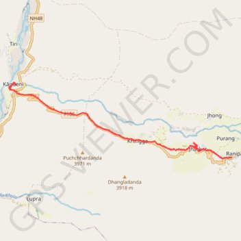
Tour Annapurna - Jour 11 - Muktinath - Kagbeni
Randonnée pédestre. Entre Ranipauwa et Kagbeni. #Randonnée
- Distance : 11,8 Km
- Dénivelé positif : 92 m
- Altitude maximum : 3 668 m
- Dénivelé négatif : 920 m
- Altitude minimum : 2 837 m
- Temps en mouvement : 3 h 23 m
- Vitesse en mouvement : 3,5 Km/h
- Vitesse maximum : 13,8 Km/h
- Temps total : 5 h 33 m
- Vitesse globale : 2,1 Km/h
- Date : 10/04/2014
Carte interactive
Profil de la trace GPS
À propos de cette trace GPS
Nom : Trace GPS Tour Annapurna - Jour 11 - Muktinath - Kagbeni, itinéraire, parcours
Coordonnées : 28.81457 83.78294 28.83820 83.86179
Topographie : Carte topographique मुस्ताङ
Autres traces GPS
Cliquez sur une trace GPS pour visualiser son itinéraire, ses statistiques et son profil.
Tour Annapurna - Jour 12 - Kagbeni - Marpha
Népal > Gandaki > मुस्ताङ > Ekle Bhatti
Randonnée entre Kagbeni et Jomsom. #Randonnée
Distance : 17,2 Km • Dénivelé positif : 358 m • Altitude maximum : 2 860 m