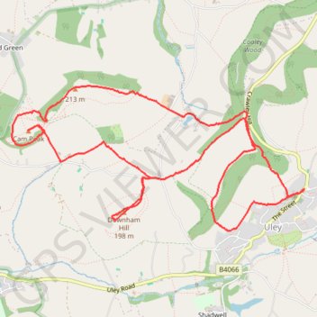
Walk through Uley, Cam Peak, and Downham Hill
- Distance : 10,0 Km
- Dénivelé positif : 409 m
- Altitude maximum : 231 m
- Dénivelé négatif : 409 m
- Altitude minimum : 104 m
- Temps en mouvement : 2 h 45 m
- Vitesse en mouvement : 3,6 Km/h
- Vitesse maximum : 8,9 Km/h
- Temps total : 3 h 36 m
- Vitesse globale : 2,8 Km/h
- Date : 05/05/2024
Carte interactive
Profil de la trace GPS
À propos de cette trace GPS
Nom : Trace GPS Walk through Uley, Cam Peak, and Downham Hill, itinéraire, parcours
Départ : The Green, Uley, Stroud, Gloucestershire, England, GL11 5SN, United Kingdom (51.68610 -2.30212)
Arrivée : The Green, Uley, Stroud, Gloucestershire, England, GL11 5SN, United Kingdom (51.68603 -2.30234)
Coordonnées : 51.68284 -2.33925 51.69422 -2.30212
Autres traces GPS
Cliquez sur une trace GPS pour visualiser son itinéraire, ses statistiques et son profil.
Cam Peak
United Kingdom > England > Gloucestershire > Stroud > Nympsfield
Distance : 13,1 Km • Dénivelé positif : 400 m • Altitude maximum : 242 m
Dean2023-311
United Kingdom > England > Oxfordshire > Oxford
Distance : 310,3 Km • Dénivelé positif : 3 366 m • Altitude maximum : 290 m