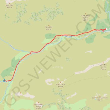
Planned eMTB Gravel: Linn of Dee -> The Red House Bothy - TnB
Following the River Dee west from the Linn of Dee
- Distance : 15,2 Km
- Dénivelé positif : 100 m
- Altitude maximum : 441 m
- Dénivelé négatif : 100 m
- Altitude minimum : 373 m
- Temps en mouvement : 1 h 9 m
- Vitesse en mouvement : 13,2 Km/h
- Vitesse maximum : 29,7 Km/h
- Temps total : 1 h 53 m
- Vitesse globale : 8,0 Km/h
- Date : 31/03/2024
Carte interactive
Profil de la trace GPS
À propos de cette trace GPS
Nom : Trace GPS Planned eMTB Gravel: Linn of Dee -> The Red House Bothy - TnB, itinéraire, parcours
Départ : Linn of Dee, C1M, Aberdeenshire, Scotland, AB35 5YB, United Kingdom (56.98943 -3.54308)
Arrivée : Linn of Dee, C1M, Aberdeenshire, Scotland, AB35 5YB, United Kingdom (56.98965 -3.54316)
Coordonnées : 56.96186 -3.64151 56.98965 -3.54308