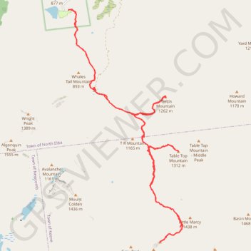
Mount Marcy, Table Top and Phelps Mountain
Hike from Heart Lake to Mount Marcy, Table Top and Phelps Mountain via Van Hoevenberg Trail, Marcy Dam, Phelps Mountain Trail, Indian Falls and Tabletop Mountain Trail in the High Peaks Wilderness and the Adirondacks Park. #Hike #Mountain #Nature #Forest #Lake #Falls #River #Wilderness #Park
- Distance : 29,5 Km
- Dénivelé positif : 1 679 m
- Altitude maximum : 1 612 m
- Dénivelé négatif : 1 679 m
- Altitude minimum : 642 m
- Temps en mouvement : 11 h 51 s
- Vitesse en mouvement : 2,7 Km/h
- Vitesse maximum : 45,3 Km/h
- Temps total : 12 h 28 m
- Vitesse globale : 2,4 Km/h
- Date : 02/08/2018
Carte interactive
Profil de la trace GPS
À propos de cette trace GPS
Nom : Trace GPS Mount Marcy, Table Top and Phelps Mountain, itinéraire, parcours
Départ : Van Hoevenberg Trail, Town of North Elba, Essex County, New York, United States (44.18299 -73.96252)
Arrivée : Van Hoevenberg Trail, Town of North Elba, Essex County, New York, United States (44.18299 -73.96243)
Coordonnées : 44.11273 -73.96252 44.18321 -73.91396
Autres traces GPS
Cliquez sur une trace GPS pour visualiser son itinéraire, ses statistiques et son profil.
Mount Marcy, Mount Skylight and Gray Peak
United States > New York > Essex County > Town of Keene > Town of Newcomb
Return hike from Mount Marcy to Heart Lake via Mount Marcy Trail, Schofield Cobble, Four Corners, Skylight Trail, Lake Tear of the Clouds, Gray Peak Trail, Van Hoevenberg Trail, Indian Falls and Marcy Dam Pond in the High Peaks Wilderness and the Adirondack Park. #Hike #Mountain #Nature #Forest #Lake #Falls #Park #Wilderness
Distance : 17,9 Km • Dénivelé positif : 607 m • Altitude maximum : 1 612 m
Mount Colden Loop
United States > New York > Essex County
Loop hike from Heart Lake to Mount Colden via Van Hoevenberg Trail, Marcy Dam Pond, Avalanche Pass Trail, Avalanche Pass, Avalanche Lake, Lake Colden, Mount Colden Trail, L. Morgan Porter Trail, Lake Arnold and Lake Arnold Trail in the High Peaks Wilderness and the Adirondack Park. #Hike #Loop #Mountain #Lake #Forest #Nature #Park…
Distance : 21,7 Km • Dénivelé positif : 1 000 m • Altitude maximum : 1 415 m
Mount Skylight
United States > New York > Essex County
Hike to Mount Skylight via Adirondack Loj Road, Heart Lake, Van Hoevenberg Trail, Marcy Dam, Avalanche Pass Trail, Avalanche Camp, Lake Arnold Trail, Lake Arnold, Mount Marcy Trail, Lake Tear of the Clouds, Four Corners and Skylight Trail in the High Peaks Wilderness and the Adirondack Park. #Hike #Mountain #Nature #Forest #Lake…
Distance : 33,0 Km • Dénivelé positif : 1 295 m • Altitude maximum : 1 492 m
Mount Redfield and Cliff Mountain
United States > New York > Essex County
Hike from Heart Lake to Mount Redfield and Cliff Mountain via Van Hoevenberg Trail, Marcy Dam, Avalanche Pass Trail, Avalanche Camp, Lake Arnold Trail, Lake Arnold, Mount Marcy Trail, Mount Redfield Trail and Cliff Mountain Trail in the High Peaks Wilderness and Adirondack Park. #Hike #Mountain #Nature #Forest #Lake #River #Park…
Distance : 29,7 Km • Dénivelé positif : 1 399 m • Altitude maximum : 1 388 m
Montréal - New York
Canada > Québec > Agglomération de Montréal > Montréal
Distance : 637,3 Km • Dénivelé positif : 4 134 m • Altitude maximum : 301 m