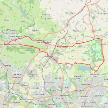
Otley - Eccup Reservoir - Harewood Bank - Otley (bicycle)
- Distance : 34,5 Km
- Dénivelé positif : 364 m
- Altitude maximum : 178 m
- Dénivelé négatif : 363 m
- Altitude minimum : 33 m
- Temps en mouvement : 1 h 49 m
- Vitesse en mouvement : 19,0 Km/h
- Vitesse maximum : 47,4 Km/h
- Temps total : 1 h 49 m
- Vitesse globale : 19,0 Km/h
- Date : 14/04/2024
Carte interactive
Profil de la trace GPS
À propos de cette trace GPS
Nom : Trace GPS Otley - Eccup Reservoir - Harewood Bank - Otley (bicycle), itinéraire, parcours
Coordonnées : 53.86736 -1.71330 53.90983 -1.50634
Autres traces GPS
Cliquez sur une trace GPS pour visualiser son itinéraire, ses statistiques et son profil.
Otley Chevin
United Kingdom > England > Leeds > Otley
Distance : 8,8 Km • Dénivelé positif : 238 m • Altitude maximum : 278 m
Otley - Eccup Reservoir - Harewood Bank - Otley (bicycle)
United Kingdom > England > Leeds > Otley
Distance : 34,9 Km • Dénivelé positif : 377 m • Altitude maximum : 179 m