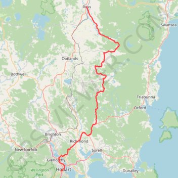
Ross - Hobart
Carte interactive
Profil de la trace GPS
À propos de cette trace GPS
Nom : Trace GPS Ross - Hobart, itinéraire, parcours
Départ : Church Street, Ross, Northern Midlands, Tasmania, 7209, Australia (-42.03103 147.49223)
Arrivée : Glen Street, South Hobart, Hobart, City of Hobart, Tasmania, 7000, Australia (-42.89453 147.30865)
Coordonnées : -42.89468 147.29466 -42.03103 147.72436
Autres traces GPS
Cliquez sur une trace GPS pour visualiser son itinéraire, ses statistiques et son profil.
Droughty Ridgeline Trail North (Rokeby Hills)
This trail runs the ridgeline of the Rokeby Hills Bushland Reserve. Starting at the end of Mayfair Crt enter the reserve and head straight up to the top of Kuynah reserve. From here there are blue markers(arrows) to keep users on the primary ridgeline track which is also the fire trail along the reserve. The trail is relatively low…
Distance : 3,9 Km • Dénivelé positif : 121 m • Altitude maximum : 155 m
South Hobart - Wellington Park - Pipeline Track
Distance : 21,3 Km • Dénivelé positif : 988 m • Altitude maximum : 636 m