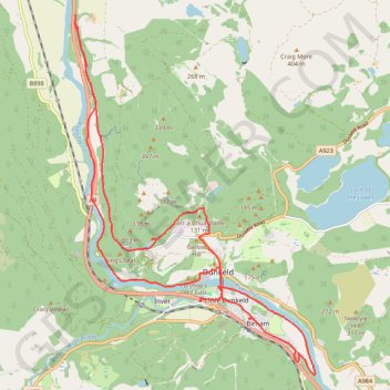
Mountain Bike Ride Around Dunkeld, Perthshire Scotland
Loop MTB via Polney Loch, River Tay, Dunkeld Cathedral, Dunkeld Bridge, River Braan, Birnam, Ring Wood and Birnam Riverside Path. #MTB #Loop #Nature #Forest #River
- Distance : 21,4 Km
- Dénivelé positif : 347 m
- Altitude maximum : 149 m
- Dénivelé négatif : 347 m
- Altitude minimum : 48 m
- Temps en mouvement : 1 h 28 m
- Vitesse en mouvement : 14,5 Km/h
- Vitesse maximum : 43,7 Km/h
- Temps total : 1 h 51 m
- Vitesse globale : 11,5 Km/h
- Date : 08/04/2024
Carte interactive
Profil de la trace GPS
À propos de cette trace GPS
Nom : Trace GPS Mountain Bike Ride Around Dunkeld, Perthshire Scotland, itinéraire, parcours
Coordonnées : 56.54950 -3.62644 56.60530 -3.55896
Autres traces GPS
Cliquez sur une trace GPS pour visualiser son itinéraire, ses statistiques et son profil.
Walk over A9 bridge over River Braan by pedestrian pavement (sidewalk) and small diversion for SGN gas pipeline route then Fiddlers path
United Kingdom > Scotland > Perth and Kinross > Dunkeld
Distance : 6,0 Km • Dénivelé positif : 79 m • Altitude maximum : 76 m