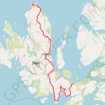
Skye Trail
- Distance : 127,4 Km
- Dénivelé positif : 3 959 m
- Altitude maximum : 655 m
- Dénivelé négatif : 3 995 m
- Altitude minimum : 1 m
Carte interactive
Profil de la trace GPS
À propos de cette trace GPS
Nom : Trace GPS Skye Trail, itinéraire, parcours
Départ : North Duntulm Road, Shulista, Highland, Écosse, IV51 9UG, Royaume-Uni (57.68397 -6.32589)
Arrivée : 4, A87, Broadford, Highland, Écosse, IV49 9BF, Royaume-Uni (57.24139 -5.90929)
Coordonnées : 57.14208 -6.34477 57.70113 -5.90929
Topographie : Carte topographique Highland
Autres traces GPS
Cliquez sur une trace GPS pour visualiser son itinéraire, ses statistiques et son profil.
The Old Man of Storr
Royaume-Uni > Écosse > Highland
GPX file from Walkhighlands; file is copyright Walkhighlands and must not be publicly shared on other websites. Do not remove this notice.
Distance : 5,1 Km • Dénivelé positif : 335 m • Altitude maximum : 493 m
Fairy Pools
Royaume-Uni > Écosse > Highland
Distance : 6,7 Km • Dénivelé positif : 236 m • Altitude maximum : 280 m
Elgol to Camasunary dans les Cuillin
Royaume-Uni > Écosse > Highland > Elgol
Distance : 14,9 Km • Dénivelé positif : 527 m • Altitude maximum : 189 m
The Storr - ascent
Royaume-Uni > Écosse > Highland
GPX file from Walkhighlands; file is copyright Walkhighlands and must not be publicly shared on other websites. Do not remove this notice.
Distance : 7,9 Km • Dénivelé positif : 569 m • Altitude maximum : 708 m
Storr to Portree coast
Royaume-Uni > Écosse > Highland
GPX file from Walkhighlands; file is copyright Walkhighlands and must not be publicly shared on other websites. Do not remove this notice.
Distance : 11,2 Km • Dénivelé positif : 431 m • Altitude maximum : 383 m
Hebrideanway
Royaume-Uni > Écosse > Na h-Eileanan Siar > Baile Bhatarsaigh
Distance : 322,3 Km • Dénivelé positif : 4 198 m • Altitude maximum : 268 m