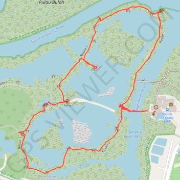
Sungei Buloh Wetland Route
Enjoy the tranquility and serenity of the mangrove habitat is through Route 1. This route goes around the two main ponds and gives a good introduction to the Reserve and the birds of Sungei Buloh, especially during the migratory season from September to March
From https://www.aussiebushwalking.com/overseas/sungei-buloh-wetland-route-1
- Distance : 2,6 Km
- Dénivelé positif : 16 m
- Altitude maximum : 9 m
- Dénivelé négatif : 16 m
- Altitude minimum : 0 m
- Temps en mouvement : 48 m 36 s
- Vitesse en mouvement : 3,2 Km/h
- Vitesse maximum : 6,7 Km/h
- Temps total : 1 h 17 m
- Vitesse globale : 2,0 Km/h
- Date : 04/11/2017
Carte interactive
Profil de la trace GPS
À propos de cette trace GPS
Nom : Trace GPS Sungei Buloh Wetland Route, itinéraire, parcours
Coordonnées : 1.44398 103.72410 1.44970 103.72903
Autres traces GPS
Cliquez sur une trace GPS pour visualiser son itinéraire, ses statistiques et son profil.
Directions from Duck Tour Ramp to Marina Boulevard, Singapore
Singapore > Central > Singapore
Distance : 105,3 Km • Dénivelé positif : 812 m • Altitude maximum : 51 m
Kualanamu International Airport to Jakarta, Indonesia
Indonésie > Sumatra du Nord > Deli Serdang > Beringin
Distance : 1 809,2 Km • Dénivelé positif : 10 977 m • Altitude maximum : 125 m