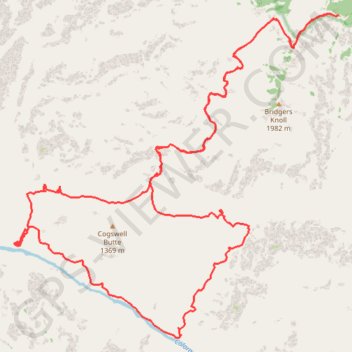
Cogswell Butte Loop (Grand Canyon)
Loop hike from Bill Hall Trailhead around Cogswell Butte via Bill Hall Trail, Thunder River Trail, Thunder River Falls, Tapeats Creek Trail, Colorado River, Deer Creek Trail, Deer Creek Falls and Deer Spring in the Grand Canyon National Park. #Hike #Loop #Canyon #Mountain #River #Falls #Nature #Park
- Distance : 45,5 Km
- Dénivelé positif : 3 462 m
- Altitude maximum : 2 198 m
- Dénivelé négatif : 3 462 m
- Altitude minimum : 595 m
Carte interactive
Profil de la trace GPS
À propos de cette trace GPS
Nom : Trace GPS Cogswell Butte Loop (Grand Canyon), itinéraire, parcours
Départ : NF-292A, Coconino County, Arizona, United States (36.43478 -112.42981)
Arrivée : NF-292A, Coconino County, Arizona, United States (36.43478 -112.42979)
Coordonnées : 36.37077 -112.50982 36.43507 -112.42979