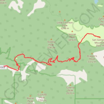
San Gorgonio Mountain via Vivian Creek Trail
Carte interactive
Profil de la trace GPS
À propos de cette trace GPS
Nom : Trace GPS San Gorgonio Mountain via Vivian Creek Trail, itinéraire, parcours
Départ : Falls Trailhead, San Bernardino County, California, United States (34.08212 -116.89348)
Arrivée : Falls Trailhead, San Bernardino County, California, United States (34.08212 -116.89347)
Coordonnées : 34.07959 -116.89348 34.10140 -116.82487
Autres traces GPS
Cliquez sur une trace GPS pour visualiser son itinéraire, ses statistiques et son profil.
San Gorgonio Mountain (Vivian Creek Trail)
United States > California > San Bernardino County
Hike to the San Gorgonio Mountain by the Vivian Creek Trail in the San Gorgonio Wilderness. #Hike #Mountain #Nature #Forest #Wilderness
Distance : 14,3 Km • Dénivelé positif : 1 670 m • Altitude maximum : 3 502 m
Dobbs Cabin
United States > California > San Bernardino County > Forest Falls
Hike to Dobbs Cabin Camp by the Momyer Creek Trail, the Fals Creek Trail and the Dobbs Cabin Spur in the San Gorgonio Wilderness, the Sand to Snow National Monument and the San Bernardino National Forest. #Hike #Mountain #Forest #Nature #Wilderness
Distance : 9,1 Km • Dénivelé positif : 851 m • Altitude maximum : 2 290 m
San Gorgonio Mountain (South Fork Trail)
United States > California > San Bernardino County
Hike to San Gorgonio Mountain via South Fork Trail, Poopout Hill, Dollar Lake Saddle, San Bernardino Peak Trail and San Gorgonio Mountain Trail in the Sand to Snow National Monument and the San Gorgonio Wilderness. #Hike #Mountain #Nature #Forest #Wilderness
Distance : 15,2 Km • Dénivelé positif : 1 425 m • Altitude maximum : 3 502 m