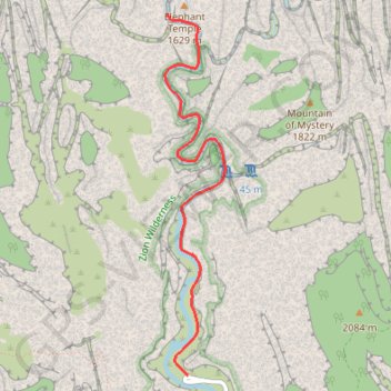
The Narrows
Hike along the Virgin River from the Temple of Sinawava to The Narrows via the Riverside Walk, the Mystery Canyon Falls and the Floating Rock in the Zion National Park. #Hike #Canyon #River #Mountain #Zion #Rock
- Distance : 4,5 Km
- Dénivelé positif : 550 m
- Altitude maximum : 1 527 m
- Dénivelé négatif : 408 m
- Altitude minimum : 1 351 m
Carte interactive
Profil de la trace GPS
À propos de cette trace GPS
Nom : Trace GPS The Narrows, itinéraire, parcours
Coordonnées : 37.28526 -112.94971 37.31018 -112.94443
Autres traces GPS
Cliquez sur une trace GPS pour visualiser son itinéraire, ses statistiques et son profil.
The Narrows
United States > Utah > Washington County > Zion Lodge
Hike along Virgin River to The Narrows from Temple of Sinawava via Riverside Walk, The Narrows Day Hike Section, Mystery Canyon Falls, 200' Waterfall, House Rock and Floating Rock in the Zion National Park. #Hile #Canyon #River #Rock #Nature #Park #Falls #Zion
Distance : 11,3 Km • Dénivelé positif : 1 579 m • Altitude maximum : 1 583 m