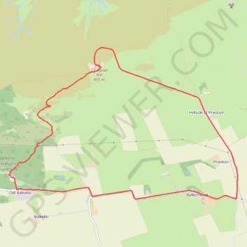
Craigowl Hill Loop
Loop run / hike from Balkello Community Woodland to Craigowl Hill. #Run #Hike #Loop #Nature #Forest #Countryside
- Distance : 9,3 Km
- Dénivelé positif : 310 m
- Altitude maximum : 451 m
- Dénivelé négatif : 310 m
- Altitude minimum : 153 m
- Temps en mouvement : 1 h 2 m
- Vitesse en mouvement : 8,9 Km/h
- Vitesse maximum : 28,0 Km/h
- Temps total : 1 h 19 m
- Vitesse globale : 7,0 Km/h
- Date : 01/03/2024
Carte interactive
Profil de la trace GPS
À propos de cette trace GPS
Nom : Trace GPS Craigowl Hill Loop, itinéraire, parcours
Coordonnées : 56.53164 -3.03471 56.54998 -2.98456