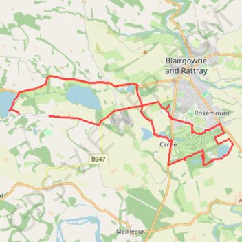
Around Blairgowrie, Scotland
Loop bike around Blairgowrie, Marlee Loch, Loch of Clunie, White Loch, Rosemount Golf Course and Stormont Loch. #Bike #Loop #Nature #Lake #Countryside #Forest
- Distance : 22,8 Km
- Dénivelé positif : 174 m
- Altitude maximum : 102 m
- Dénivelé négatif : 192 m
- Altitude minimum : 46 m
- Temps en mouvement : 1 h 43 m
- Vitesse en mouvement : 13,2 Km/h
- Vitesse maximum : 35,0 Km/h
- Temps total : 2 h 11 s
- Vitesse globale : 11,4 Km/h
- Date : 08/03/2024
Carte interactive
Profil de la trace GPS
À propos de cette trace GPS
Nom : Trace GPS Around Blairgowrie, Scotland, itinéraire, parcours
Départ : Craigie, Perth and Kinross, Scotland, PH10 6RD, United Kingdom (56.57664 -3.41737)
Arrivée : Craigie, Perth and Kinross, Scotland, PH10 6RD, United Kingdom (56.57701 -3.43456)
Coordonnées : 56.56083 -3.44046 56.58913 -3.31184
Autres traces GPS
Cliquez sur une trace GPS pour visualiser son itinéraire, ses statistiques et son profil.
The Knockie, Marlee Loch and Loch of Clunie Loop
United Kingdom > Scotland > Perth and Kinross > Craigie
Loop MTB / run / hike around Blairgowrie via The Knockie, Marlee Loch and Loch of Clunie. #Hike #Loop #Nature #Countryside #Lake
Distance : 17,2 Km • Dénivelé positif : 271 m • Altitude maximum : 203 m