Lac Viti - Lac Mývatn
- Distance : 18,0 Km
- Dénivelé positif : 201 m
- Altitude maximum : 609 m
- Dénivelé négatif : 498 m
- Altitude minimum : 281 m
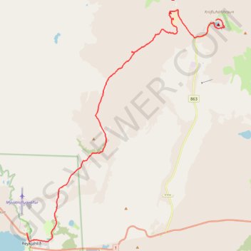
Carte interactive
Profil de la trace GPS
À propos de cette trace GPS
Nom : Trace GPS Lac Viti - Lac Mývatn, itinéraire, parcours
Départ : Kröfluvegur, Þingeyjarsveit, Norðurland eystra, Islande (65.71841 -16.75536)
Arrivée : Reynihlíð, Reykjahlíð, Þingeyjarsveit, Norðurland eystra, Islande (65.64492 -16.91408)
Coordonnées : 65.64194 -16.91408 65.72226 -16.74813
Topographie : Carte topographique Þingeyjarsveit
Autres traces GPS
Cliquez sur une trace GPS pour visualiser son itinéraire, ses statistiques et son profil.
Lac Viti - Lac Mývatn
Distance : 18,0 Km • Dénivelé positif : 202 m • Altitude maximum : 609 m