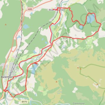
Aviemore to Loch Garten: A Tale of Trails and Trials
- Distance : 35,4 Km
- Dénivelé positif : 261 m
- Altitude maximum : 244 m
- Dénivelé négatif : 261 m
- Altitude minimum : 202 m
- Temps en mouvement : 3 h 29 m
- Vitesse en mouvement : 10,1 Km/h
- Vitesse maximum : 33,9 Km/h
- Temps total : 4 h 27 m
- Vitesse globale : 7,9 Km/h
- Date : 01/05/2024
Carte interactive
Profil de la trace GPS
À propos de cette trace GPS
Nom : Trace GPS Aviemore to Loch Garten: A Tale of Trails and Trials, itinéraire, parcours
Départ : B9152, Aviemore, Highland, Scotland, PH22 1PX, United Kingdom (57.18327 -3.83335)
Arrivée : B9152, Aviemore, Highland, Scotland, PH22 1PX, United Kingdom (57.18319 -3.83326)
Coordonnées : 57.17698 -3.83385 57.25063 -3.68692
Autres traces GPS
Cliquez sur une trace GPS pour visualiser son itinéraire, ses statistiques et son profil.
Glenmore - Meall a' Bhuachaille - Ryvoan Bothy
United Kingdom > Scotland > Highland > Glenmore
Distance : 8,8 Km • Dénivelé positif : 564 m • Altitude maximum : 807 m