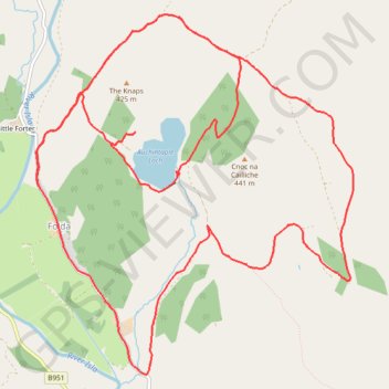
EMTB Gravel: Auchintaple Loch Loop
Around Auchintaple Loch, nr Folda, Angus
- Distance : 15,7 Km
- Dénivelé positif : 394 m
- Altitude maximum : 457 m
- Dénivelé négatif : 394 m
- Altitude minimum : 282 m
- Temps en mouvement : 1 h 40 m
- Vitesse en mouvement : 9,4 Km/h
- Vitesse maximum : 30,1 Km/h
- Temps total : 2 h 4 m
- Vitesse globale : 7,6 Km/h
- Date : 04/04/2024
Carte interactive
Profil de la trace GPS
À propos de cette trace GPS
Nom : Trace GPS EMTB Gravel: Auchintaple Loch Loop, itinéraire, parcours
Coordonnées : 56.75239 -3.33108 56.77665 -3.29213
Autres traces GPS
Cliquez sur une trace GPS pour visualiser son itinéraire, ses statistiques et son profil.
Spittal of Glenshee to Alyth - Some of the Cateran Trail
United Kingdom > Scotland > Perth and Kinross > Spittal of Glenshee
Distance : 38,3 Km • Dénivelé positif : 561 m • Altitude maximum : 459 m
Alyth to Spittal of Glenshee - Cateran Trail (some of)
United Kingdom > Scotland > Perth and Kinross > Alyth
Distance : 44,2 Km • Dénivelé positif : 1 134 m • Altitude maximum : 650 m