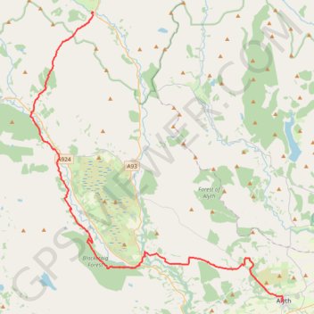
Alyth to Spittal of Glenshee - Cateran Trail (some of)
- Distance : 44,2 Km
- Dénivelé positif : 1 134 m
- Altitude maximum : 650 m
- Dénivelé négatif : 899 m
- Altitude minimum : 99 m
- Temps en mouvement : 4 h 3 m
- Vitesse en mouvement : 10,9 Km/h
- Vitesse maximum : 43,2 Km/h
- Temps total : 4 h 41 m
- Vitesse globale : 9,4 Km/h
- Date : 04/05/2024
Carte interactive
Profil de la trace GPS
À propos de cette trace GPS
Nom : Trace GPS Alyth to Spittal of Glenshee - Cateran Trail (some of), itinéraire, parcours
Départ : Albert Street, Alyth, Perth and Kinross, Scotland, PH11 8AA, United Kingdom (56.62128 -3.23327)
Arrivée : Spittal of Glenshee, Perth and Kinross, Scotland, PH10 7QE, United Kingdom (56.81373 -3.46002)
Coordonnées : 56.62128 -3.53599 56.81403 -3.23014
Autres traces GPS
Cliquez sur une trace GPS pour visualiser son itinéraire, ses statistiques et son profil.
Spittal of Glenshee to Alyth - Some of the Cateran Trail
United Kingdom > Scotland > Perth and Kinross > Spittal of Glenshee
Distance : 38,3 Km • Dénivelé positif : 561 m • Altitude maximum : 459 m
Around Kirkmichael, Perthshire
United Kingdom > Scotland > Perth and Kinross > Kirkmichael
Distance : 7,8 Km • Dénivelé positif : 88 m • Altitude maximum : 274 m
Around Bridge of Cally
United Kingdom > Scotland > Perth and Kinross > Bridge of Cally > Netherton
Distance : 13,3 Km • Dénivelé positif : 282 m • Altitude maximum : 293 m
EMTB Gravel: Auchintaple Loch Loop
United Kingdom > Scotland > Angus > Folda > Little Forter
Around Auchintaple Loch, nr Folda, Angus
Distance : 15,7 Km • Dénivelé positif : 394 m • Altitude maximum : 457 m